Oil & Gas
From the assessment of a single well site to the development of complex oil and gas facilities, our team understands the specific issues that affect your project. We provide a full range of consulting services including engineering and land surveying. Lamp Rynearson’s talented team of experts are prepared to address all parts of the permitting process, navigate local processes, and understand the regulatory agencies. Our all-inclusive team will act as an extension of your operations from project planning to design and construction.
Energy Development Solutions.
Navigate the ever-changing COGCC permitting process with the Lamp Rynearson team. We are well-versed in the Oil and Gas Development Plan process and can provide the necessary drawings, maps, and exhibits required to reach approval.
- Alternative Location Analysis
- Cultural Distances
- Location Pictures
- Location Drawings
- Layout Drawing
- Wildlife Habitat Drawing
- Hydrology Map
- Access Road Map
- Related Location and Flowline Map
- Directional Well Plats
- Geologic Hazard Map
- Disproportionately Impacted Communities Map
- Interim Reclamation Plan
- Stormwater Management Plan
In addition to these drawings, we can provide support for additional 2A/2B documentation, data, and reports.
Lamp Rynearson has multitudes of experience developing Form 2 submittal requirements, including Well Location Plats, Wellbore Diagrams, and Drilling and Spacing Units, and more. Our survey crews are capable of surveying and measuring real world section corners to produce high accuracy plats.
The oil & gas team has experience with local jurisdictions all across Colorado, including Weld County, Frederick, Greeley, Evans, Commerce City, and Adams County. Whether you need approvals through the Weld County WOGLA or Adam’s County USR, we have the tools and connections to successfully get you through the process.
Gone are the days of oil and gas permitting in rural areas. Many sites today are incorporated in multi-use subdivisions. Lamp Rynearson has the experience of not only permitting well pads in these areas, while minimizing the impact to the surrounding community. With site planning experience in commercial, residential, and industrial areas, we can help your site fit seamlessly into your community.
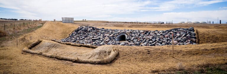
Once state and local permits have been obtained, it’s time for construction. Lamp Rynearson’s design engineers will produce a Construction Drawing plan set to help you accomplish all of your design goals. Including grading, drainage, and erosion control, our engineers know how to tackle all aspects of your project. Earthwork balances and material quantities, are just a small part of the overall analysis that goes into the construction design.
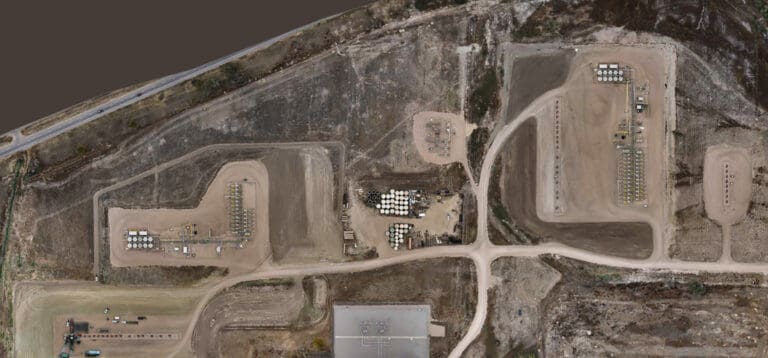
Utilizing a combination of quadcopter and fixed-wing style drones, we are able the fly both small and large areas confidently and efficiently to map anything that is required. Photogrammetry and LiDAR technologies are a part of the toolset. The processing options include an orthorectified mosaic image of the flight area, a digital surface model in the form of a point cloud, and the creation of a digital surface in ACAD drawing formats utilizing the data captured.
Topographic surveys are completed to a high standard of precision and accuracy by experienced Lamp Rynearson crews. With the latest in total station and GPS technology at our fingertips, we can complete topographic surveys on any structures or over any terrain.
The preparation of property descriptions and exhibits are performed by a licensed land surveyor or under their direct supervision. Exhibits for surface use agreements, easements, right-of-ways, and general property transfers are a part of the service.
Lamp Rynearson can assist in the acquisition of stormwater discharge permits and prepare the necessary stormwater management plans to minimize erosion and sediment impacts to your site and surrounding areas. For pad sites within floodplains and floodways, we have the experience needed to prepare the necessary documents to acquire floodplain development permits. When working in the floodway, the Lamp Rynearson team can provide a no-rise analysis to ensure upstream and downstream safety.
With Lamp Rynearson’s surveying, scanning, and drone flight capabilities, as-builts have never been easier. Not only can we as-built the above ground facilities, equipment, and pad, but we can as-built the below ground utilities, flowlines, and pipelines. With custom GIS capabilities for each site, managing your assets is easier than ever.